
If you’re a geospatial professional that relies on accurate positioning for GIS spatial analysis, mapping, or informed decision making, then you probably use an RTK (real-time kinematic) correction service. The level of accuracy required for your data collection may change from project to project, but regardless of your specific requirements, an RTK correction service improves project planning and enhances efficiency.
As an early adopter of Point One Navigation’s Polaris RTK Network, Tri-Global began offering Orbitas Correct to clients in 2023. We’re happy to announce that we now offer Orbitas Correct True RTK to provide you with the precision you need for even your most demanding requirements.
Orbitas Correct, powered by Point One Navigation, delivers centimeter-level RTK (real-time kinematic) corrections for GIS, mapping, and survey applications inside of Orbitas. Unlike most RTK services, Orbitas Correct applies corrections automatically inside of Orbitas without users having to sign into an additional service.
For stakers and surveyors that already use Orbitas, that means your workflow is automated and uninterrupted. For geospatial professionals that don’t already use Orbitas, then purchasing Orbitas Correct gives you all the benefits of an Orbitas Basic subscription to expand your asset management capabilities while also applying automatic RTK corrections as you collect.
Orbitas Correct is compatible with Asteri GNSS receivers, communicates with GPS, GLONASS, Galileo, BeiDou, and QZSS satellite constellations, allows you to easily switch between local and ITRF correction datums, and features RTCM-3.2 MSM4 data delivery over NTRIP – all at a fraction of the cost of competitors.
For dependable, high-precision where consistent nationwide coverage is most important, Orbitas Correct Virtual RTK is the best option.
Built for applications where precision is paramount, Orbitas True RTK is the best option for applications with the tightest tolerances.
Connecting to Orbitas Correct is simple. Once Orbitas Correct is applied to your account by a Tri-Global representative, it begins automatically applying RTK corrections to your data in the background with no additional sign-on necessary and no extra steps for you.
To highlight the distinct advantages of both Orbitas Virtual RTK and True RTK, we conducted a test at the DAWG Monument in Athens, Georgia. This real-world demonstration provides clear insights into the performance differences, showcasing how each service meets specific precision needs and workflow requirements.
By examining the data below, you’ll understand how Orbitas Correct can significantly enhance your geospatial projects and improve your data collection efficiency, even for projects with the most demanding requirements.
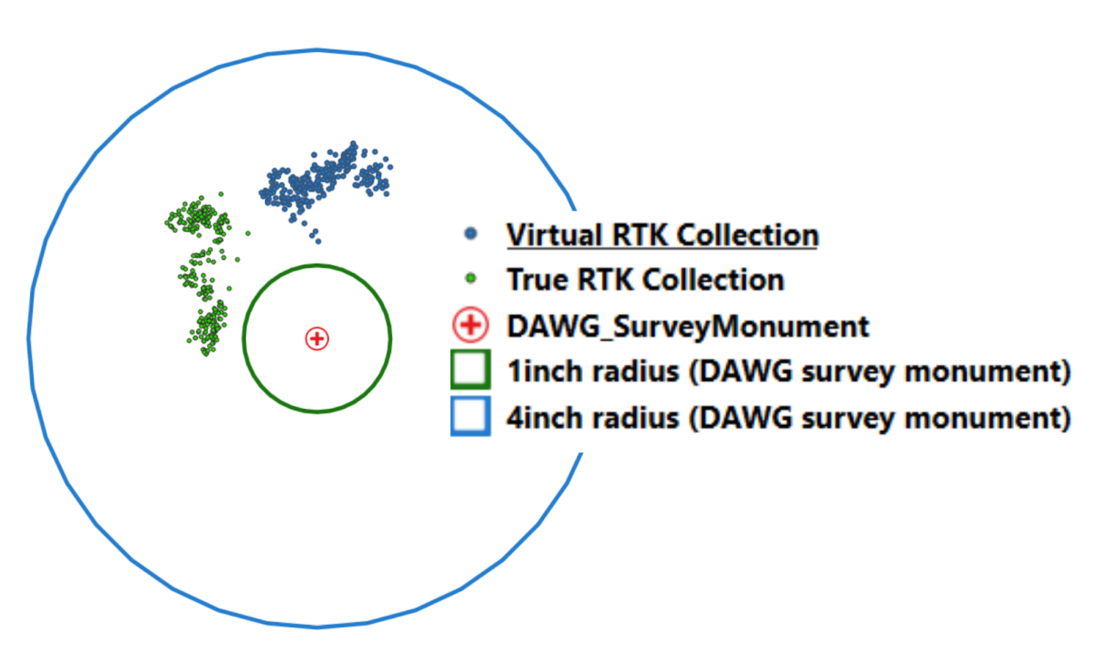
In the scatter graph pictured above, we can see that the average distance from the survey monument using the Orbitas Correct True RTK service was just over 4-centimeters and just over 5-centimeters for Orbitas Correct Virtual RTK, while the standard precision values for both services were 1-centimeter. How is this possible?
Orbitas Correct Virtual RTK is capable of 10-centimeter accuracy or better throughout the entirety of the United States, while Orbitas Correct True RTK offers 3-centimeter or better. The key difference between these two services is that Orbitas Correct True RTK has some gaps in coverage where Orbitas Correct Virtual RTK does not.
To make up for this, Orbitas Correct True RTK has the added benefit of allowing base stations to be added to the network for regions without full coverage. For clients seeking reliable, sub-inch accuracy in regions with poor base station coverage where setting up your own base station would be necessary, we recommend the Orbitas Correct True RTK service. Please contact a representative at Tri-Global for more information or help by sending an email to info@triglobal.net.
For our mapping clients, we highly recommend using the Orbitas Correct Virtual RTK service because of its incredible precision for lining in poles and locating utilities. As demonstrated in the data above, the precision of Orbitas Correct Virtual RTK rivals that of a True RTK network in most situations. In areas of the United States where there is a heavy concentration of base stations, such as at the DAWG Monument here in Athens, Georgia where we complete our testing, we see almost identical results for the two services.
Powered by Point One Navigation, Tri-Global now offers Orbitas Correct Virtual RTK and True RTK, catering to a wide range of precision needs for geospatial professionals. From the reliable, nationwide coverage of Virtual RTK to the pinpoint accuracy of True RTK, Orbitas Correct streamlines workflows with seamless integration within the Orbitas platform. By automating RTK corrections and eliminating the need for additional logins, Orbitas Correct enhances efficiency and accuracy, ensuring that users can confidently complete projects.
Whether you require dependable high-precision anywhere in the country or the tightest tolerances for high-stakes projects, Orbitas Correct provides versatile and cost-effective corrections for GIS spatial analysis, mapping, and informed decision making.
Yes, Orbitas Correct delivers data over NTRIP (Networked Transport of RTCM via Internet Protocol) and requires the internet for transmission. NTRIP allows GNSS receivers to receive correction data from a base station without direct radio communication, eliminating range limitations and offering more flexibility.
If you need data corrections in the field but cannot rely on an internet connection, Tri-Global Technologies offers two solutions. For those using the Asteri X3i, we recommend Hemisphere’s Atlas H10 service. Atlas H10 achieves 4-centimeter short-term precision and 10-centimeter long-term accuracy, and is available in 1-month, 3-month, 1-year, 3-year, and 5-year subscriptions to suit your collection needs for all types of projects.
If you’re using the Asteri X4i, you can avoid the additional expense and utilize the built-in PPP (precise point positioning) capability. While PPP has a longer convergence time, it uses a global network of reference stations to make corrections without the use of local base stations. For more information on PPP and the Asteri X4i, check out our blog post, Precise Point Positioning Service: A Blessing and a Curse.
Yes, Hemisphere’s Atlas H10 service is compatible with other GNSS receivers. Contact your GNSS provider for more information on compatibility and applying the service to your device.
No, you cannot purchase an Atlas H10 subscription from Tri-Global for use on any device other than an Asteri GNSS receiver. Atlas H10 subscriptions are exclusively available from the company that supports your GNSS device, not from other GNSS vendors. You will need to contact your GNSS provider for more information on compatibility and applying the service to your device.
ITRF (International Terrestrial Reference Frame) is a global, dynamic reference frame for accurate positioning using latitude, longitude, height, and time. ITRF relies on a broad network of ground reference stations, offering high accuracy while accounting for the movement of the Earth’s crust. While technically distinct, WGS84 is often aligned with ITRF and is best suited for worldwide applications and GPS.
Local correction datums, such as NAD83 (North American Datum of 1983), are best suited for applications using state survey monuments, such as the DAWG monument where we tested Orbitas Correct.
For applications where precision is critical, a worldwide correction datum such as ITRF or WGS should be used. NAD83 was specifically designed to fit the North American plate, causing its center to be slightly offset from the Earth’s center of mass by roughly 2.2 meters, depending on your location.
Offering the ability to easily switch between local and worldwide datums makes Orbitas Correct an excellent solution for data correction. You can read more about GNSS Accuracy in our 2022 blog post, Asteri X3i and GNSS Accuracy Explained.
Orbitas Correct is designed exclusively for Asteri GNSS receivers. However, Tri-Global also offers Point One Navigation’s Polaris RTK service, which can be used with other software capable of applying RTK corrections. While Polaris RTK provides the same high accuracy, it may require configuration of the RTK solution in your chosen software. Using Asteri GNSS receivers with Orbitas and Orbitas Correct simplifies the process, eliminating configuration complexities and potential confusion.
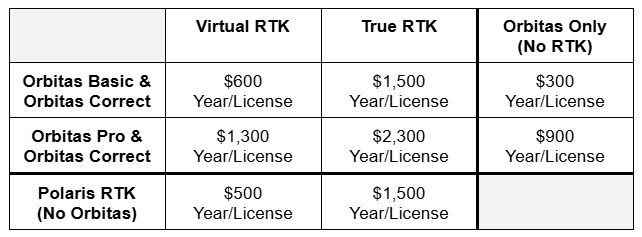
How much is an Orbitas Correct subscription?
Orbitas Correct requires a Orbitas Basic or Pro subscription. Pricing for Orbitas Correct varies based on your chosen or current Orbitas subscription, with each option featuring a $100 annual discount per Orbitas license. Details of the pricing structure can be found in the table provided below.
Orbitas is a mobile data collection application that comes with our web-based management tool, Orbitas RMS (Resource Management System). Orbitas allows geospatial professionals across industries to collect, analyze, and manage data in an intuitive and powerful environment.
Users can set up their own coordinate systems, apply custom configurations, store photos, create templates to increase efficiency, perform calculations in the field, and export data into nearly any format needed to integrate with your existing workflow. Orbitas is compatible with Asteri GNSS receivers, including the Asteri X4i, and can also be used to further enhance your data management in conjunction with other GIS software applications.