Unlock the true power of Orbitas with these advanced tools you’re not using (but should be)
Written by Raiana Kelly
At Tri-Global, we pride ourselves on building powerful, precise tools that meet the highest standards of geospatial professionals like yourself. While many of our Orbitas users are experts in the field, we often find that some of our most powerful features - designed to streamline complex workflows, save time, and solve common problems - are underutilized. We want to shine light on a few of these lesser-known advanced tools, why they’re useful, and how you can implement them in your own collection.

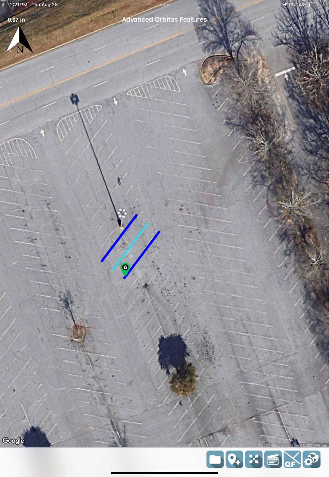
When you need to divide an angle with absolute precision, the angle bisect tool in Orbitas goes beyond simple division, offering a powerful solution, especially for professionals in the electric utility field. The angle bisect tool precisely bisects an angle at its vertex, creating a dividing line that extends outside the angle. This unique capability is invaluable for tasks like determining the exact bisector for evenly pulling utility lines, ensuring balanced force and optimal setup.
Tired of repeatedly entering the same content into a form? Streamline your workflow and ensure consistency and efficiency across all your projects in Orbitas with the assembly templates feature. This powerful feature allows you to save frequently used form data and apply it to any location within a Job, drastically reducing redundant data entry and increasing your collection speed.
Determining the correct State Plane and UTM Zone is one of the most fundamental and frustrating steps for geospatial professionals, but with Orbitas, the guesswork is eliminated. When using Orbitas, the correct coordinate system is selected for you based on your collection data, so you don’t have to worry about keeping track of which coordinate system you need to use. This is especially powerful if you’re working across multiple zones or near state lines, as Orbitas calculates the weighted average of your entire project to ensure you get the most accurate fit. Plus, you still have the option to manually select your coordinate system or zone if needed.
Do you ever need a linear offset on either side of the line you’re collecting? The Buffer in Field feature automates this process, minimizing mistakes, reducing collection time, and allowing you to create dynamic buffers around any straight or curved line, with the buffer distance automatically populated from a field in your dataset. This capability is crucial for complex projects where buffer distances may vary and need to be easily updated, such as along a roadside for engineering projects, along property lines, or before a harvest cut in forestry to account for a federally protected area.
Orbitas features a custom naming convention that allows users to define a prefix, a suffix, and an incrementing or sequential number, automatically generating unique and consistent names for your collected data. This is especially useful while traveling down a road and assigning a street name and number to your collected points, as the sequential name can be set to increase by any value. While the increment portion of the custom naming convention must be a number, users have the freedom to use any desired characters for the prefix and suffix. It should be noted that not all exports will support special characters, such as shapefiles. Custom naming convention in Orbitas ensures standardization and efficiency in your data collection, making organization a breeze.
Sometimes the point we need to measure is inaccessible, blocked by an obstacle, or too dangerous to approach. In these scenarios, a standard measurement is impossible, but your need for accuracy is absolutely critical. The offset with bearing tool solves this problem with simplicity; by taking at least two measurements from known, accessible points and then applying a precise distance and bearing, you can accurately calculate the position of the target point. This is a powerful way to collect critical data points in Orbitas without ever having to physically occupy the location, ensuring your field work is both efficient and safe. While “span bearing” is a term commonly used in the electric utility industry, the core functionality of this tool extends across various sectors, providing invaluable precision for any professional that needs to measure points remotely.
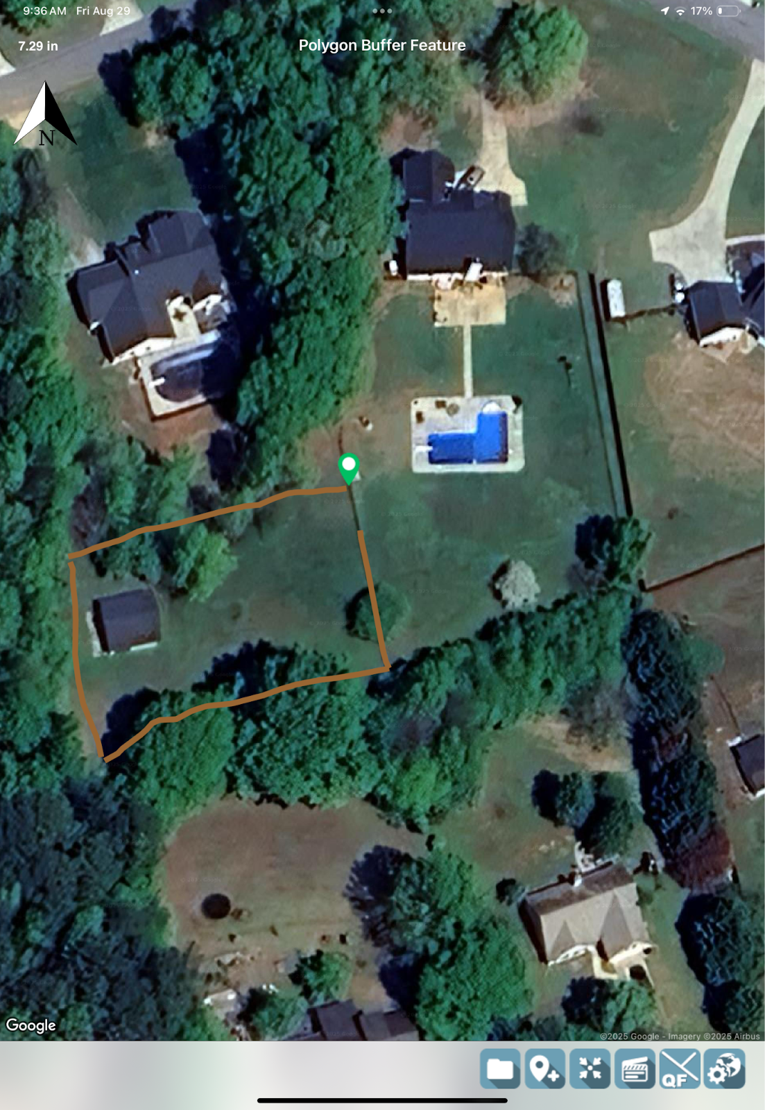
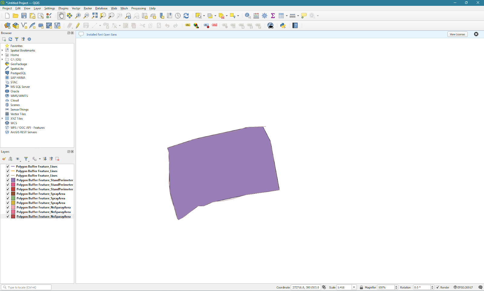
What if you need a buffer for a non-linear collection, such as a polygon? Orbitas’ Polygon Buffer feature allows you to quickly and accurately create a custom buffer around a polygon with an unlimited number of sides (minimum two) that will automatically close where you end your collection. Whether you’re defining a building’s setback from a property line, accounting for spray guidance, or creating a new zone of influence, the Polygon Buffer tool provides a clear, precise solution to a common workflow problem.

Relational features are a key component of Orbitas’ power, enabling users to construct intelligent geometric networks by collecting points and assigning multiple attributes to them. Consider a field engineer in the electric industry who needs to collect a point on a line and simultaneously associate various attributes like a transformer assembly, a capacitor, a guy wire, an anchor, or a lightning arrestor.
Orbitas empowers users to define each feature individually and then precisely attach or relate it to a single point or location. Furthermore, Orbitas’ relational features offer the flexibility to choose whether or not a collected attribute becomes part of the geometric network (“on line” or “off line”). This means you can have attributes that are inherently linked to a line but retain the ability to include or exclude them from the network as needed, providing precision control over your data’s structure and representation.
The span off tool allows Orbitas users to subdivide the length between two points into individual spans that are either specifically defined or determined by a minimum and maximum distance. Orbitas will automatically evenly distribute the spans between the two points. This is particularly helpful in cases where you cannot see the space between two points due to foliage, buildings, or other obstructions. The span off tool ensures a straight line for cost reduction and efficiency, transforming what used to be a three-person crew job into a one-person job. It also enables users to navigate back to the points in-line, making it incredibly useful for anyone who needs to segment a line they cannot physically see. With the calculate and mark button, precise segmentation is made simple.
“I will use the [span off tool] for just 2 spans or up to 10. You can apply the span then drive or walk the route to see if field entrances, culverts, or other high points are close by. You can easily move locations in line then re-span if needed. I think it is a very useful feature.”
- Charlie Mueller, MiEnergy Field Staker
“When you have a long segment ¼ or ½ a mile long and you need a straight line between them, you need poles every 250 to 300 feet or so. Span off helps you get reference points and helps you line in the poles between the endpoints allowing you to easily keep the poles close to the same distance apart and lined in without a transit. RTK corrections make this super accurate.”
These advanced tools are designed to empower geospatial professionals, streamlining complex workflows, enhancing accuracy, and ultimately saving valuable time. By integrating features like Angle Bisect, Assembly Templates, Automatic Coordinate Systems, Buffer in Field, Custom Naming Conventions, Offset with Bearing or Span Bearing, Polygon Buffer, Relational Features, and Span Off, Orbitas provides a comprehensive solution for efficient and precise data collection. We encourage you to explore these powerful capabilities and discover how they can transform your field operations. To learn more and implement these tools effectively, consider scheduling a professional consultation with an expert at Tri-Global Technologies.
Where can I learn more about the advanced tools in Orbitas?
You can learn more about advanced features and how to implement them into your workflow by scheduling a professional consultation with an expert at Tri-Global Technologies. Professional training consultations are available for one-on-one support or for your entire team.
Do I need the internet to use advanced tools in Orbitas?
The internet is required to use some parts of the advanced tools. For example, when using the Buffer in Field tool, an internet connection is only required when creating the buffer. After the buffer is created, you are free to continue collecting data without an internet connection. For questions about specific tools, please contact a Tri-Global representative or email us at support@triglobal.net.
What is Orbitas?
Orbitas is a mobile data collection application that comes with a web-based management tool. Orbitas allows geospatial professionals across industries to collect, analyze, and manage data in an intuitive and powerful environment.
Users can set up their own coordinate systems, apply custom configurations, store photos, create templates to increase efficiency, perform calculations in the field, and export data into nearly any format needed to integrate with your existing workflow. Orbitas is compatible with all Asteri GNSS receivers, including the Asteri X4i, and can also be used to further enhance your data management in conjunction with other GIS software applications.
Is Orbitas compatible with other collection software?
Yes, Orbitas can be used in conjunction with other collection applications through data imports. Orbitas can import job data from specially formatted .xls files, allowing you to prepare work in another application and bring it into the Orbitas platform. We also support integration tools with select business partners, such as Orbitas DataBridge, powered by Partner Software.
What GNSS hardware is compatible with Orbitas?
Orbitas is designed to work specifically with Asteri GNSS receivers. Asteri GNSS receivers are designed to integrate with nearly any GIS software environment. With data streaming in the NMEA format, the Asteri GNSS receiver is compatible with Orbitas, Diamond Maps Offline, ESRI ArcGIS, Geolantis.360, Milsoft FieldSyte, Partner Field Design, QField, RC Map, UTELinspect, and more. By using Orbitas in conjunction with your existing collection software, you can take your data management to the next level and get the most out of the Asteri GNSS receivers.
What is Orbitas Correct?
Orbitas Correct, powered by Point One Navigation, delivers centimeter-level RTK (real-time kinematic) corrections for GIS, mapping, and survey applications inside of Orbitas. Unlike most RTK services, Orbitas Correct applies corrections automatically inside of Orbitas without users having to sign into an additional service.
For stakers and surveyors that already use Orbitas, that means your workflow is automated and uninterrupted. For geospatial professionals that don’t already use Orbitas, then purchasing Orbitas Correct gives you all the benefits of an Orbitas Basic subscription to expand your asset management capabilities while also applying automatic RTK corrections as you collect.
How much is an Orbitas or Orbitas Correct subscription?
Orbitas Correct requires a Orbitas Basic or Pro subscription. Pricing for Orbitas Correct varies based on your chosen or current Orbitas subscription, with each option featuring a $100 annual discount per Orbitas license. Details of the pricing structure can be found in the table provided below.


